
Intense heat and severe storms are creating dangerous weather conditions across the United States this week, with 66 million people at risk for severe weather on Friday, June 12, 2026. The dual weather threats have already caused significant damage in the Midwest while record-breaking temperatures baked the East Coast on Thursday.
Thursday marked the third-most-active storm day of 2026, with 500 total storm reports recorded nationwide. More than a dozen tornadoes touched down in Illinois, Indiana and Wisconsin, while the East Coast experienced dangerous heat with Raleigh, North Carolina reaching 101 degrees Fahrenheit.
Main developments
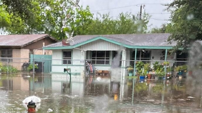
The severe weather outbreak on Thursday, June 11, 2026, left a trail of destruction across multiple Midwestern states. In Streator, Illinois, an entire cul-de-sac was ravaged by tornadoes, resulting in 11 homes sustaining damage. Four people received minor injuries in the Streator area during the storms.
In one dramatic rescue, a couple was trapped under rubble in a demolished home and had to be pulled to safety. In a separate incident, a man was trapped under debris with a broken leg and was rescued by police. Despite the widespread damage and multiple rescues, no storm-related deaths have been reported as of Friday morning.
Beyond the tornadoes, large hail battered cars in Iowa, while flooded roads and blinding rain created hazardous conditions from Wisconsin to Pennsylvania. In Dearborn, Michigan, a 6-year-old was injured when a tree fell during the storms.
On the East Coast, the extreme heat prompted New York to open cooling centers on Thursday. Heat index values reached between 95 to 105 degrees across the region, creating dangerous conditions for vulnerable populations.
What we know so far
Friday, June 12, 2026 is expected to be the last hot day for the East Coast before temperatures moderate. However, 66 million people remain at risk for severe storms on Friday across two separate regions in the country.
The storm threat will continue through the weekend, affecting millions of people across the mid-Atlantic, Midwest and Plains regions. Saturday, June 13, 2026 poses a severe storm risk with 14 million people at risk from northern Oklahoma to Illinois and Iowa. Wind gusts greater than 75 mph are expected, along with hail greater than 2 inches in diameter.
On Sunday, June 14, 2026, the severe weather threat shifts to the mid-Atlantic region, where 23 million people will be at risk for damaging gusts exceeding 60 mph.
Meanwhile, record heat is expected to build on the West Coast beginning Sunday and continuing into Monday, June 15, 2026. Temperatures in the upper 90s to low 100s are forecast for the region.
What happens next
The severe weather pattern shows no signs of easing through the weekend. Residents across the affected regions should prepare for continued storm activity over the next several days.
Friday brings the highest number of people at risk, with 66 million Americans in areas where severe storms may develop. The threat zone spans two distinct regions, meaning storms could impact communities across a wide swath of the country.
Saturday’s storm threat will be concentrated in the Midwest and Plains, from northern Oklahoma extending through Illinois and Iowa. The 14 million people in this region should be prepared for potentially damaging winds exceeding 75 mph and large hail that could measure more than 2 inches in diameter.
By Sunday, the storm focus shifts eastward to the mid-Atlantic, where 23 million people will face risks from severe weather. Damaging wind gusts exceeding 60 mph are the primary concern for this region.
As storm activity continues in the eastern half of the country, the West Coast will begin experiencing its own extreme weather. Record heat is expected to build Sunday and Monday, with temperatures climbing into the upper 90s and low 100s.
Important details
Residents in affected areas should monitor local weather forecasts closely and have a plan in place for severe weather. The storm system that produced Thursday’s tornadoes and widespread damage will continue to generate dangerous weather through the weekend.
For those in areas experiencing extreme heat, staying hydrated and limiting outdoor activities during peak afternoon hours is essential. Heat index values between 95 to 105 degrees can create dangerous conditions, particularly for children, the elderly and those with underlying health conditions.
Cooling centers have been opened in New York and other cities experiencing extreme heat. Residents without access to air conditioning should seek out these facilities during the hottest parts of the day.
The timeline for severe weather threats is as follows:
Friday, June 12, 2026: Last hot day for the East Coast; 66 million people at risk for severe storms across two regions.
Saturday, June 13, 2026: Severe storm risk in the Midwest and Plains with 14 million at risk; wind gusts greater than 75 mph and hail greater than 2 inches possible.
Sunday, June 14, 2026: Severe storms in the mid-Atlantic with 23 million at risk; damaging gusts exceeding 60 mph expected; record heat begins on West Coast.
Monday, June 15, 2026: Continued record heat on West Coast with temperatures in the upper 90s to low 100s.
Frequently asked questions
How many tornadoes were reported on Thursday?
More than a dozen tornadoes were reported in Illinois, Indiana and Wisconsin on Thursday, June 11, 2026. The day saw 500 total storm reports, making it the third-most-active storm day of 2026.
Were there any deaths from the severe storms?
No storm-related deaths have been reported as of Friday morning, despite widespread damage and multiple rescues across the affected areas.
How many people are at risk for severe weather this weekend?
On Friday, 66 million people are at risk across two regions. Saturday sees 14 million at risk from northern Oklahoma to Illinois and Iowa. On Sunday, 23 million people in the mid-Atlantic face severe storm risks.
When will the heat wave end on the East Coast?
Friday, June 12, 2026 is expected to be the last hot day for the East Coast. However, the West Coast will begin experiencing record heat starting Sunday and continuing into Monday.
What were the temperatures recorded during the heat wave?
Raleigh, North Carolina reached 101 degrees Fahrenheit on Thursday. Heat index values across the East Coast ranged between 95 to 105 degrees.
The combination of severe storms and extreme heat represents a significant weather event affecting large portions of the United States this week. With millions of people in the path of potential severe weather through Sunday and record heat building on the West Coast, weather conditions will remain a concern for communities across the country in the coming days.