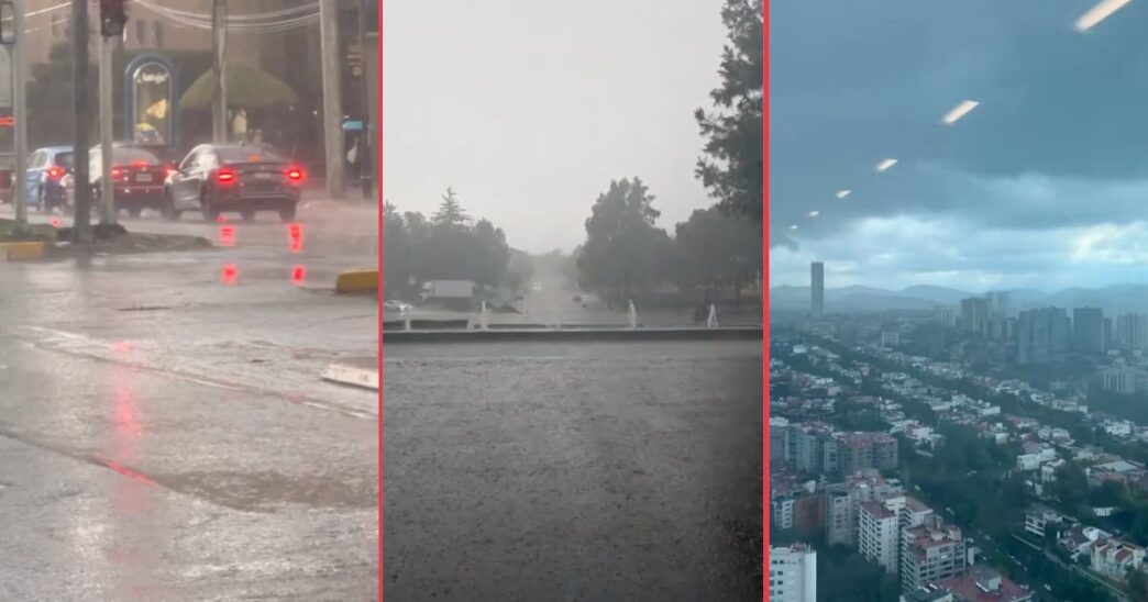
A powerful rainstorm accompanied by hail struck southern Mexico City on Friday afternoon, June 12, 2026, causing widespread flooding, severely reduced visibility, and major traffic disruptions across multiple boroughs. The storm most heavily impacted the areas of Tlalpan, Coyoacán, and Álvaro Obregón, prompting authorities to issue emergency alerts for affected zones.
The Secretary of Comprehensive Risk Management and Civil Protection activated a Yellow Alert for strong rains and possible hail in several boroughs across the Mexican capital. More critically, an Orange Alert was declared specifically for Coyoacán and Tlalpan, where forecast precipitation levels were expected to reach between 30 and 49 millimeters with accompanying hail.
Main Developments
The Friday afternoon storm brought intense rainfall and hail to southern portions of the Mexican capital, creating dangerous conditions for motorists and pedestrians. Underpasses and main roads experienced significant flooding, making travel extremely difficult throughout the affected areas.
Several major thoroughfares bore the brunt of the storm’s impact. The areas around Perisur, Insurgentes Sur, Periférico, San Fernando, and the Mexico-Cuernavaca highway all experienced hazardous driving conditions due to accumulated water and reduced visibility from the heavy precipitation.
Insurgentes Sur near Fuentes Brotantes emerged as one of the most severely affected points during the storm. The area saw significant water accumulation that disrupted normal traffic flow and created challenging conditions for drivers attempting to navigate through the zone.
Santa Úrsula also experienced considerable traffic circulation problems as a result of the storm. The combination of flooding and the sudden onset of hail created gridlock conditions that left many motorists stranded or moving at extremely slow speeds.
What We Know So Far
The intense rainstorm struck southern Mexico City during the afternoon hours of Friday, June 12, 2026. The storm brought both heavy rain and hail to the affected areas, creating a combination of hazards that complicated emergency response and traffic management efforts.
The three boroughs most impacted by the storm were Tlalpan, Coyoacán, and Álvaro Obregón, all located in the southern portion of the city. These areas saw the most significant flooding and traffic disruptions during and immediately after the storm.
Authorities responded to the weather event by activating a tiered alert system. A Yellow Alert was put in place for several boroughs across the city, warning residents of strong rains and possible hail. The more serious Orange Alert was specifically issued for Coyoacán and Tlalpan, where precipitation was forecast to reach between 30 and 49 millimeters accompanied by hail.
This Friday storm came just days after the city was still dealing with consequences from previous storms that struck on Wednesday night and Thursday morning. Those earlier weather events caused significant damage, including fallen trees, downed utility poles, and collapsed billboards across various parts of the city.
What Happens Next
Residents in the affected boroughs should continue to monitor official communications from the Secretary of Comprehensive Risk Management and Civil Protection regarding the status of weather alerts. The Orange Alert for Coyoacán and Tlalpan indicates that authorities consider these areas at elevated risk for weather-related incidents.
Emergency services were already stretched following the earlier storms that occurred Wednesday night through Thursday morning. The Miguel Hidalgo borough alone received approximately 180 emergency reports from those previous weather events, indicating the significant burden placed on first responders and city services during this period of intense storm activity.
Motorists should exercise caution when traveling through areas that experienced flooding, as road conditions may remain hazardous even after the rain subsides. Standing water in underpasses and low-lying areas can persist and create ongoing dangers for vehicles.
Important Details
The following areas experienced the most significant impacts from the Friday storm and should be approached with caution:
Perisur: This commercial and residential area saw flooding that affected traffic circulation and access to businesses and homes in the zone.
Insurgentes Sur: One of Mexico City’s major north-south arteries experienced significant disruption, with the area near Fuentes Brotantes among the hardest hit locations.
Periférico: The ring road that circles much of Mexico City saw hazardous conditions in southern sections during the storm.
San Fernando: This area experienced flooding and traffic problems during the height of the storm.
Mexico-Cuernavaca Highway: This major route connecting Mexico City to the south saw dangerous driving conditions during the storm, affecting commuters and travelers.
Santa Úrsula: Traffic circulation in this area was particularly problematic as flooding created bottlenecks and delays.
Recent Storm Activity in Mexico City
The Friday storm was not an isolated event but rather part of a pattern of intense weather affecting Mexico City in recent days. Storms that struck on Wednesday night and Thursday morning caused considerable damage throughout the metropolitan area.
These earlier storms resulted in fallen trees that blocked roads and damaged property. Utility poles were also knocked down, potentially affecting power and communication services in affected areas. Additionally, billboards collapsed under the force of the winds and rain.
The Miguel Hidalgo borough proved particularly hard hit by these earlier storms, with approximately 180 emergency reports logged by local authorities. This high volume of emergency calls demonstrates the widespread nature of the damage and the strain placed on emergency response systems.
The back-to-back nature of these storm systems means that residents and city services have had little time to fully recover between weather events. Areas that experienced damage from the Wednesday and Thursday storms may have been further impacted by Friday’s rain and hail.
Understanding the Alert System
The Secretary of Comprehensive Risk Management and Civil Protection uses a color-coded alert system to communicate weather-related risks to Mexico City residents. The activation of both Yellow and Orange Alerts during Friday’s storm indicates that authorities viewed the weather conditions as presenting genuine dangers to public safety.
The Yellow Alert issued for multiple boroughs warned residents about strong rains and the possibility of hail. This level of alert encourages residents to take precautionary measures and remain aware of changing conditions.
The Orange Alert declared for Coyoacán and Tlalpan represents a higher level of concern. This alert was issued based on forecast precipitation of 30 to 49 millimeters with hail. Residents in these boroughs were advised to take additional precautions given the elevated risk levels.
Frequently Asked Questions
Which areas of Mexico City were most affected by the June 12, 2026 storm?
The boroughs of Tlalpan, Coyoacán, and Álvaro Obregón in southern Mexico City experienced the most significant impacts. Specific areas including Perisur, Insurgentes Sur, Periférico, San Fernando, the Mexico-Cuernavaca highway, and Santa Úrsula saw flooding and traffic disruptions.
What weather alerts were issued during the Mexico City storm?
The Secretary of Comprehensive Risk Management and Civil Protection activated a Yellow Alert for strong rains and possible hail in several boroughs. An Orange Alert was declared for Coyoacán and Tlalpan, where precipitation was forecast to reach 30 to 49 millimeters with hail.
Were there other recent storms in Mexico City before the June 12 event?
Yes, storms on Wednesday night and Thursday morning before June 12 caused fallen trees, downed utility poles, and collapsed billboards. The Miguel Hidalgo borough alone received approximately 180 emergency reports from those earlier storms.
Mexico City continues to experience significant storm activity as the rainy season progresses. Residents in affected areas should remain attentive to official alerts and exercise caution when traveling, particularly in locations that experienced flooding during recent weather events.